|
1
|
|
|
2
|
- EXA is the Ecuadorian Civilian Space Agency, a civilian,
non-governmental and independent institution which objective is the
development and implementation of the Ecuadorian Space Program,
published on August 29 2007.
- On September 29 2008 by resolution of the plenary of the General
Assembly of the International Astronautical Federation (IAF), EXA is
accepted as a member of this organism.
- It is the first time in history that one Ecuadorian institution is a
full member of the IAF.
- EXA was accepted into the IAF as SPACE AGENCY
- This qualification was possible due achievements like Project DAEDALUS
an POSEIDON, showing the level of our science and technology, even in
such a short period of time – 1 year
|
|
3
|
- The Ecuadorian Space Program includes a Planetary Sciences component.
- To fulfill that role, EXA organized the Planetary Sciences Division
within the agency, in charge of the study and analysis of active
planetary systems.
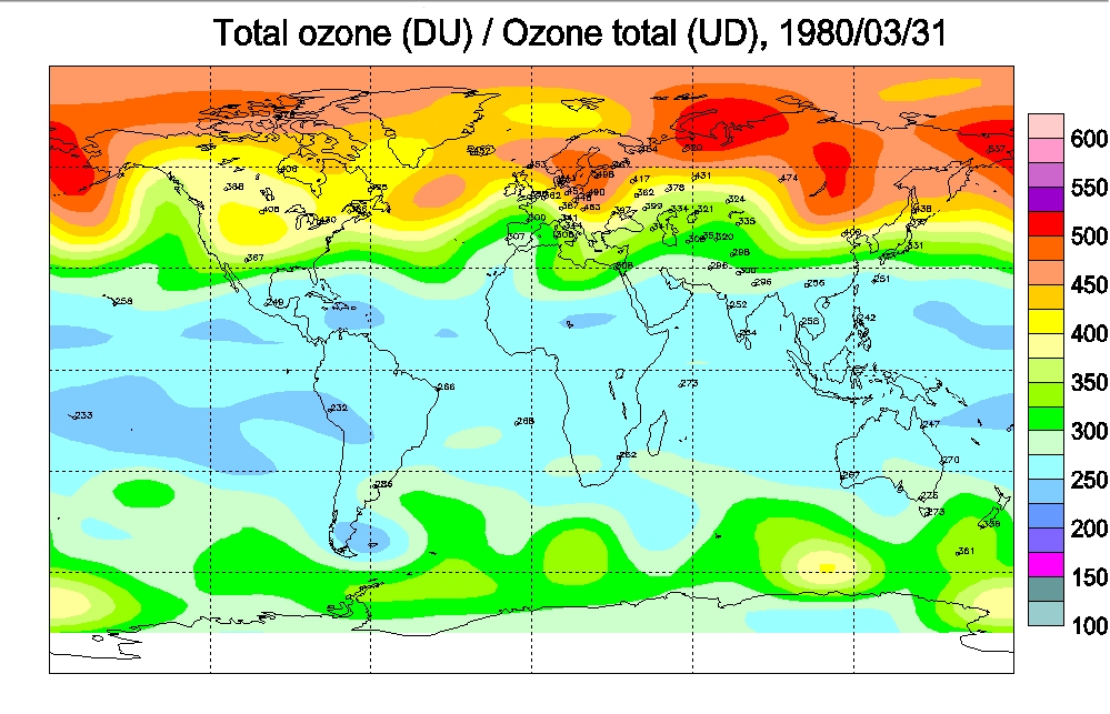
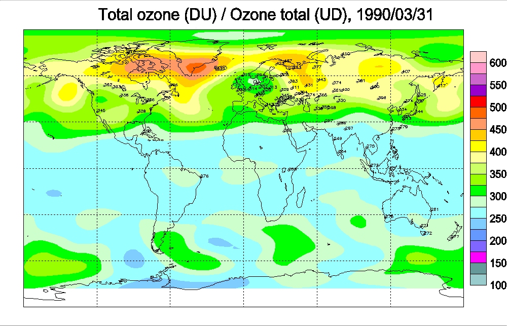
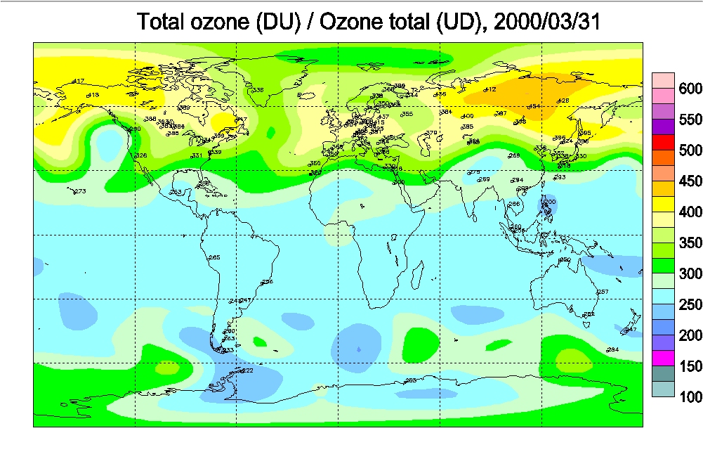
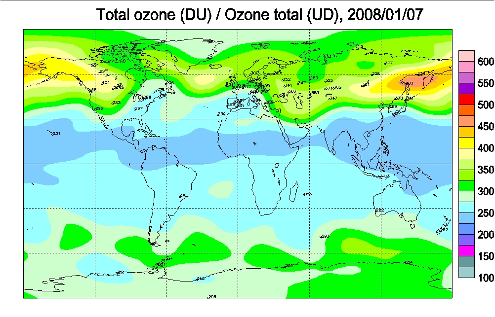
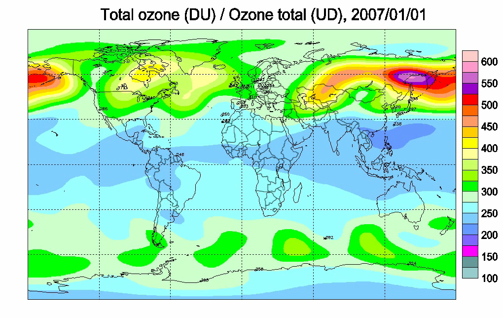
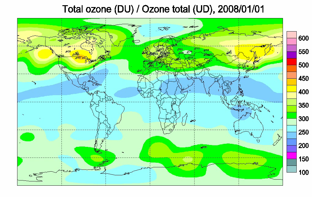
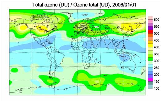
- EXA’s Planetary Sciences has been studying the phenomenon of Ozone layer
depletion over the last 12 months. Ozone is the gas that shields our
planet from harmful UV radiation from the sun.
- EXA has completed a field study using state of the art technology to
find out how much and which types of radiation are reaching the surface
of Ecuadorian territory.
- This study has been completed using our own resources and equipment
gathering our own data and using data from 12 satellites from NASA, ESA,
KNMI, Environmental CANADA and
the Meteorology Institute of Russia.
- The name of the project was HIPERION.
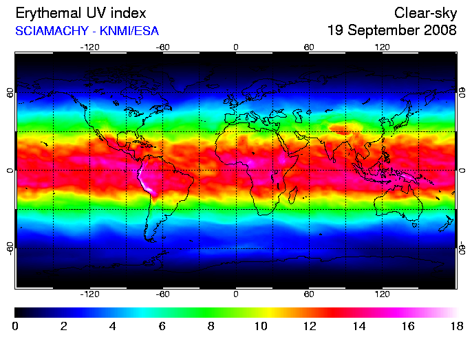
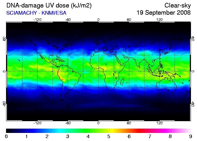
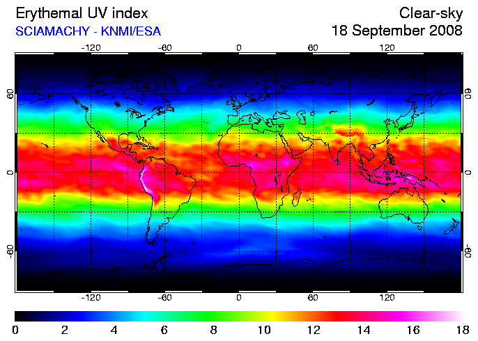
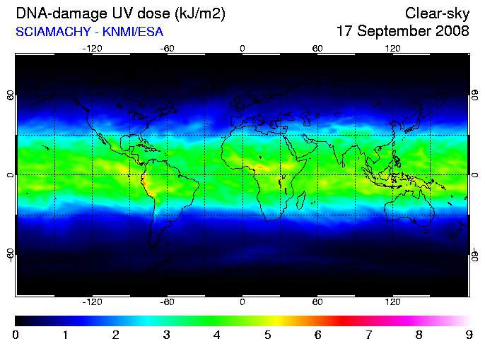
- The results are as follows:
|
|
4
|
|
|
5
|
|
|
6
|
|
|
7
|
|
|
8
|
|
|
9
|
|
|
10
|
- With that density of the ozone layer over the equatorial zone of the
planet, how much UV radiation is reaching the surface?
- What type of UV radiation is reaching surface and in which zones has
more impact?
|
|
11
|
|
|
12
|
|
|
13
|
|
|
14
|
|
|
15
|
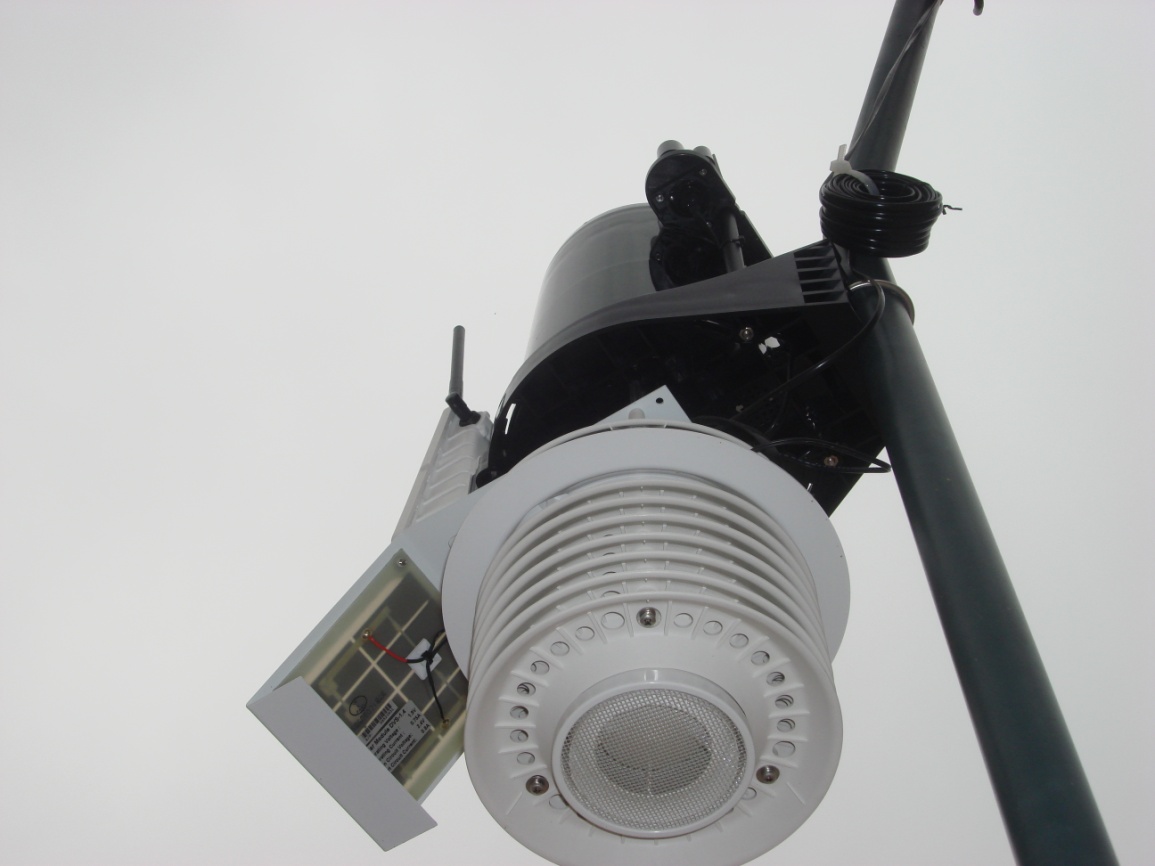
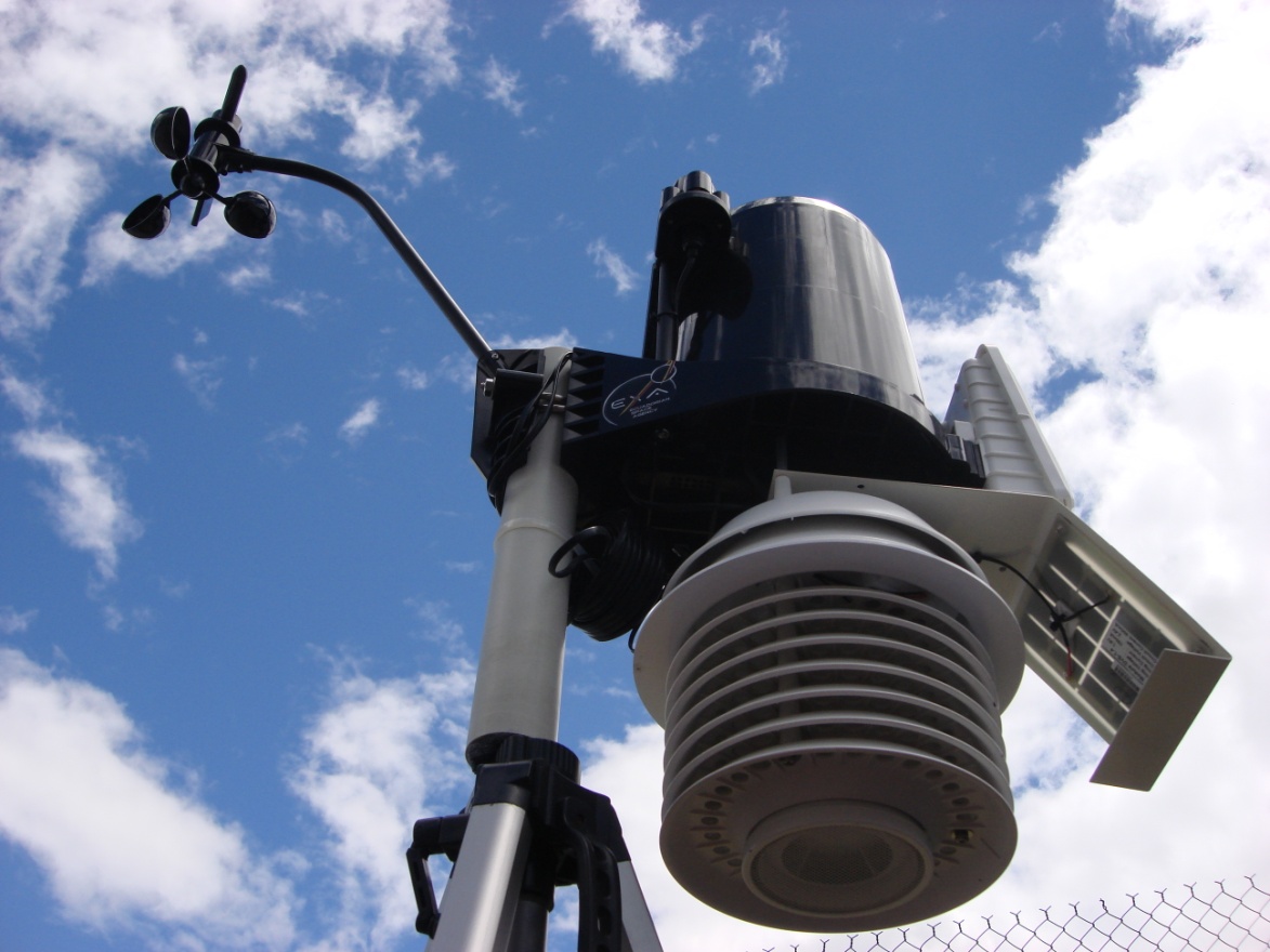
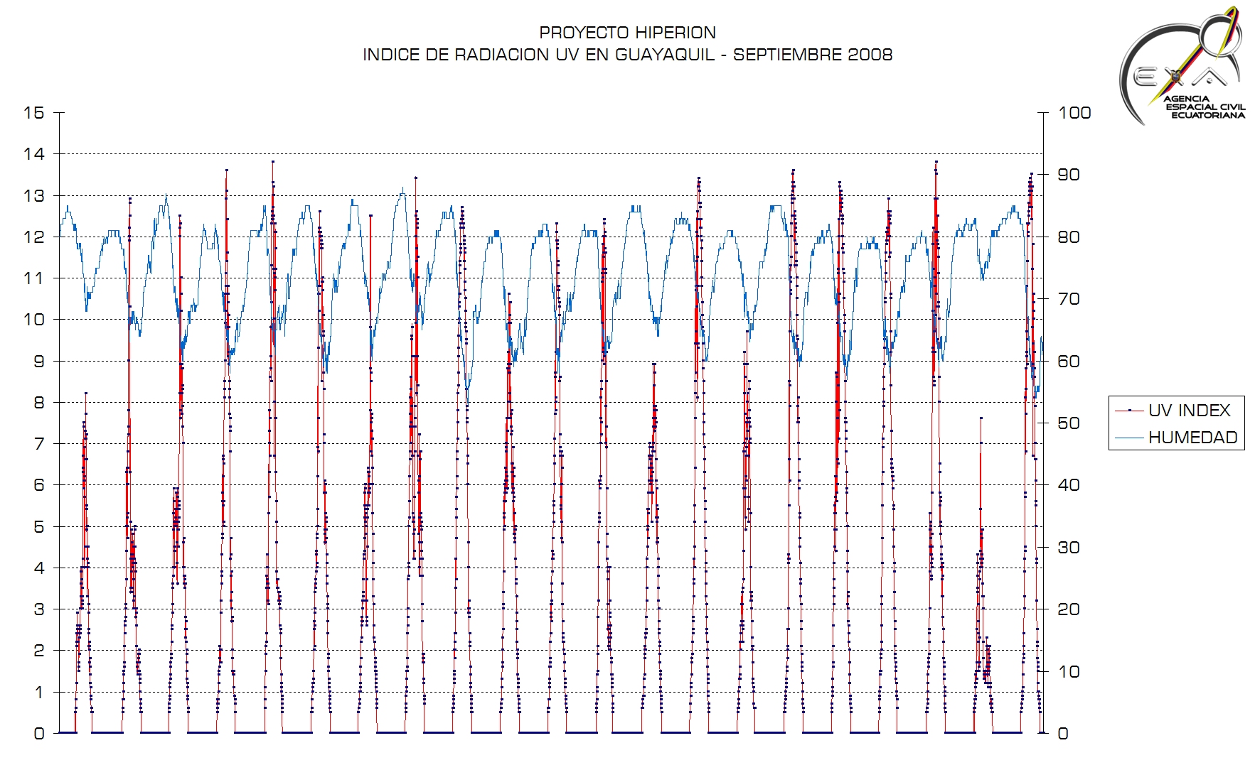
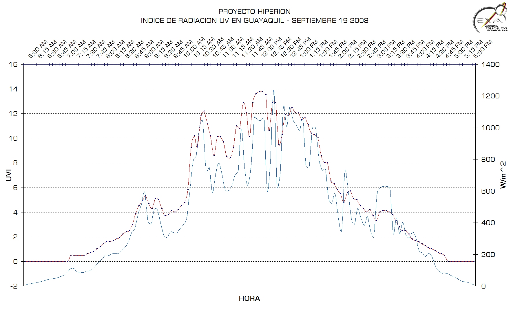
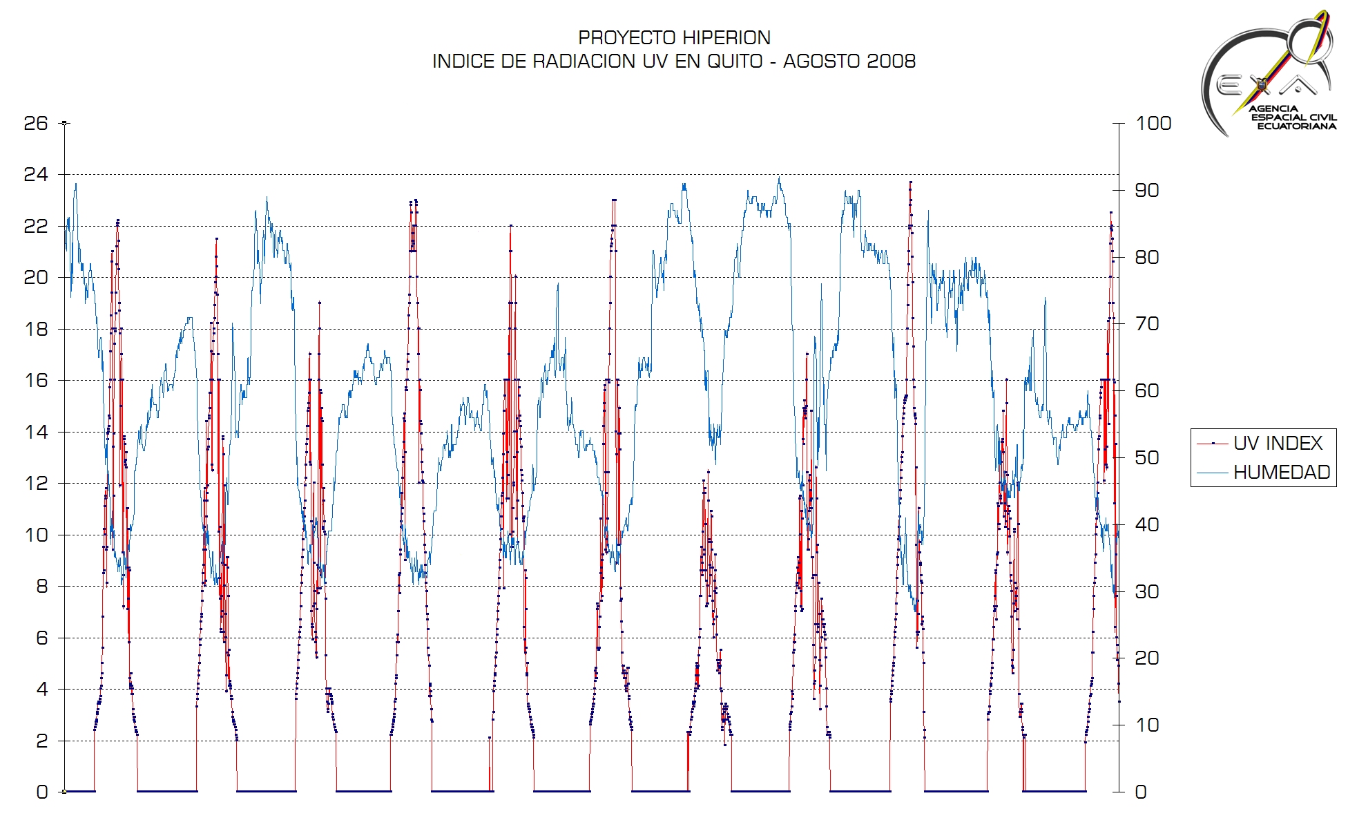
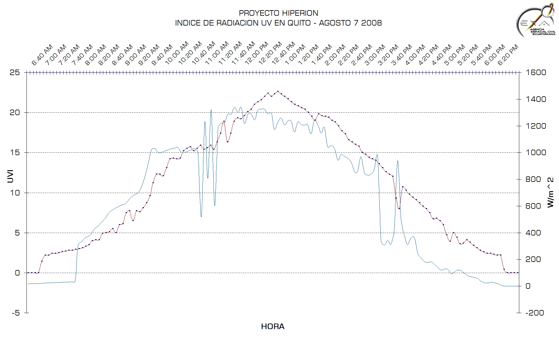
- Using completely automated systems that exclude human intervention we
have gathered data about UV radiation on GUAYAQUIL and QUITO since April
2008.
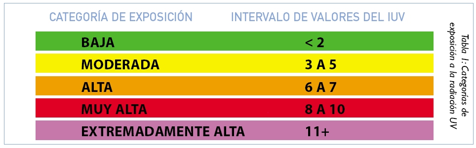
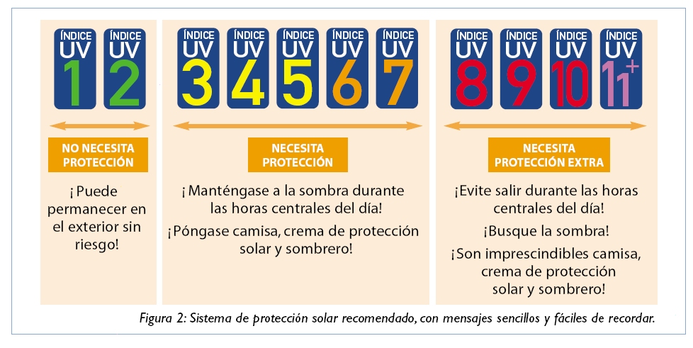
- The equipment used by EXA use the word wide standard of UV Index.
- The results are as follows:
|
|
16
|
|
|
17
|
|
|
18
|
|
|
19
|
|
|
20
|
|
|
21
|
|
|
22
|
|
|
23
|
|
|
24
|
|
|
25
|
|
|
26
|
|
|
27
|
|
|
28
|
|
|
29
|
|
|
30
|
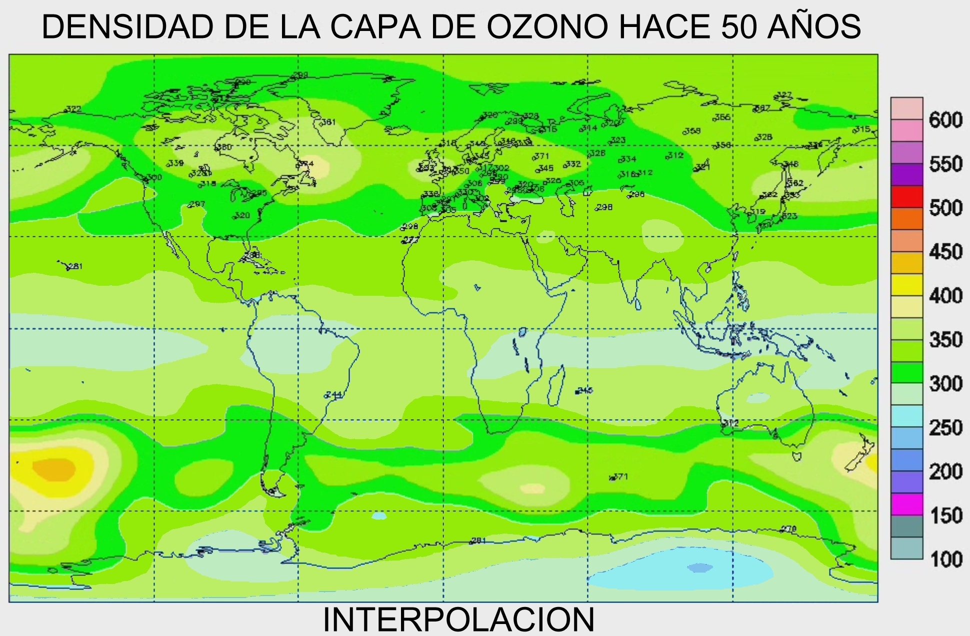
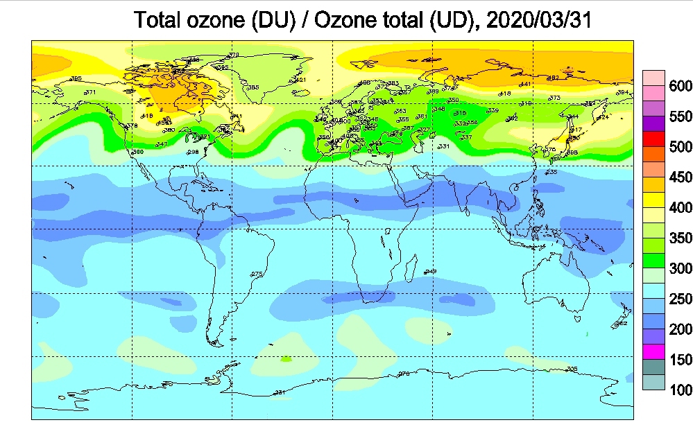
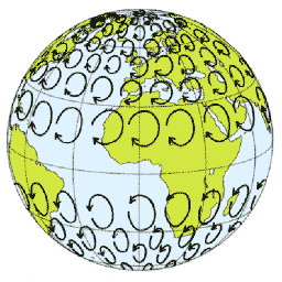
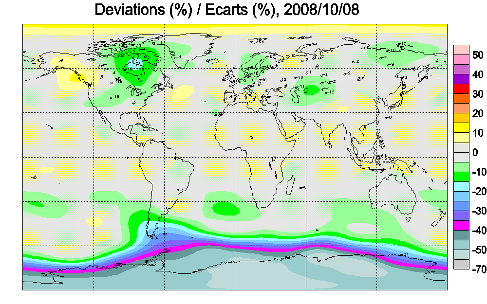
- Even when the most of the ozone is produced over equatorial areas , the
gas is redistributed pole ward thanks to the CORIOLIS effect in part.
- It is natural that a weaker density of ozone should exist over the
equatorial band, but this density should not drop below 280 Dobson
units.
- The CORIOLIS effect, among many other factors, helps define the master
wind patterns on the planets.
- When the ozone reaches south pole is destroyed there by the chlorine
present in the Polar Stratospheric Clouds PSC and the seasonal south
pole ozone hole forms , so there is not enough ozone left to maintain an
acceptable level due to this loss.
- There is also an smaller seasonal hole over the north pole.
|
|
31
|
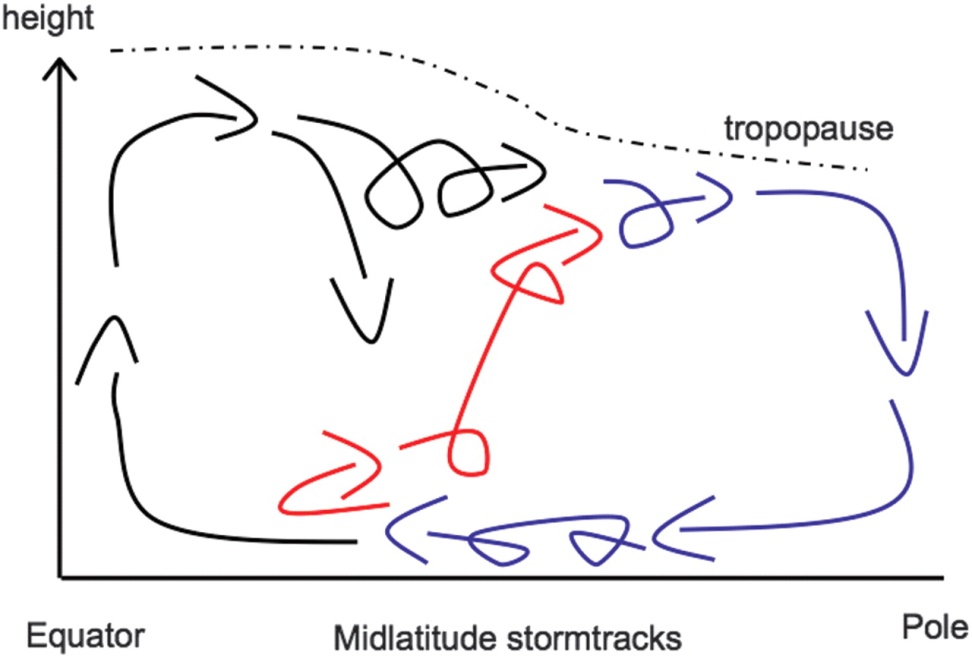
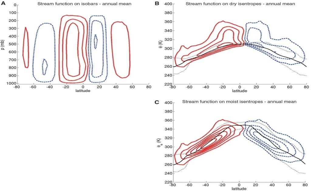
- This atmospheric circulation pattern has just recently revised by one
study published in the SCIENCE magazine of September 2008
- The study, by Pauluis (Courant Institute of Mathematical Sciences, New
York University,), Czaja (2Space and Atmospheric Physics Group,
Department of Physics, Imperial College) and Korty (3Department of
Atmospheric Sciences, Texas A&M University), details the atmospheric
redistribution pattern that sends the gases from the equator to the
poles.
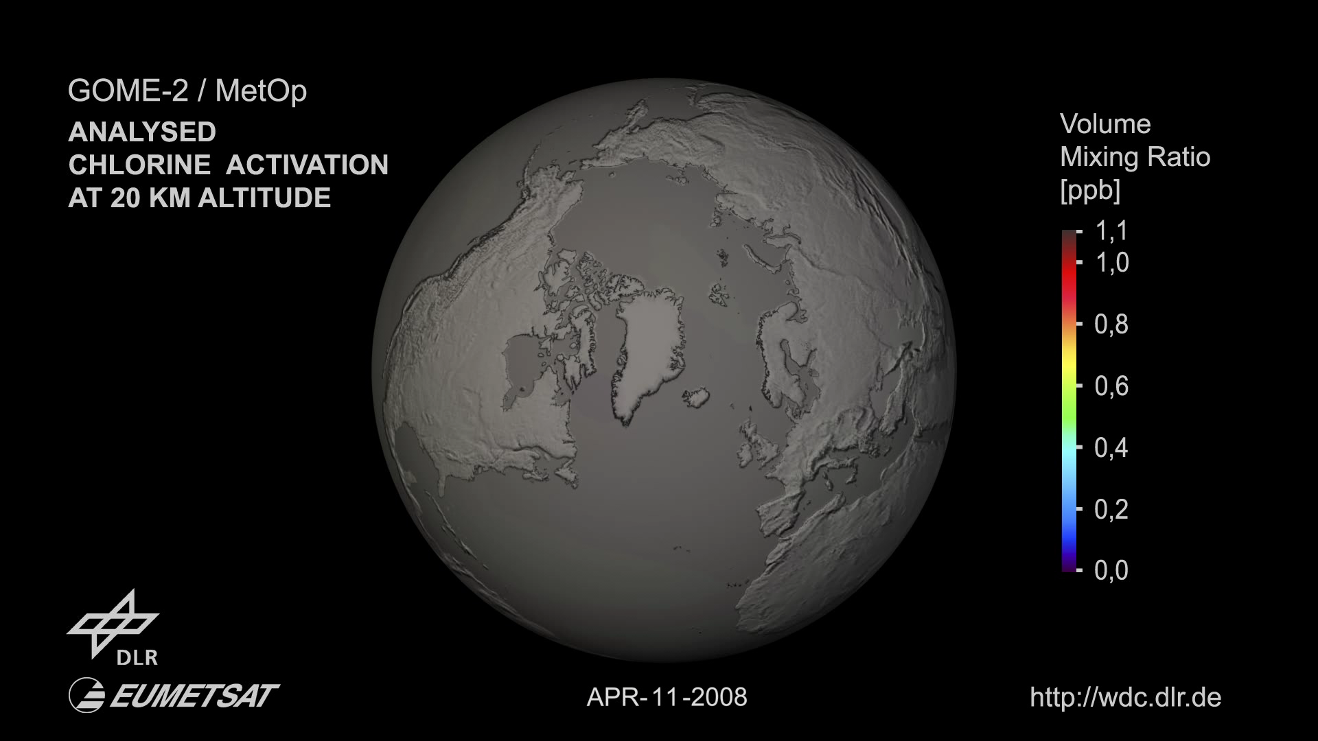
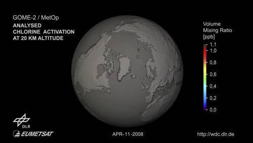
- Direct observations from the GOME-2 instrument detail the Ozone
destruction process in the south pole
|
|
32
|
|
|
33
|
|
|
34
|
- We have use satellite images dating from 1980 from reliable sources like
NASA, ESA, KNMI, Environmental CANADA and the Russian Meteorology.
- We have take ground readings using automatic equipment of proven
reliability, avoiding human intervention in the data gathering and
reading taking process.
- Satellite data are in agreement with ground data readings.
- We have abided to parameters specified by the UV index.
- We have made no data interpretation.
|
|
35
|
- The Ozone layer over equatorial regions has weakened over the last 15
years. This phenomenon could be a direct consequence of the seasonal
south pole ozone depletion.
- As a result we have verified that the UV radiation levels reaching
Ecuadorian territory EXCEEDS the last number in the WHO UV index scale
for acceptable human tolerance.
- The power of the radiation that reaches our region is the HIGHEST IN THE
PLANET and represents a clear and present danger to all the Ecuadorian,
Peruvian and Colombian population, the most affected areas are the
Andean regions.
|
|
36
|
- Due to its position in the planet, our region receives much more
radiation than the polar region, and the weakening of the ozone layer
over our coordinates occurs the whole year.
- As a result of this excessive exposition to high levels of radiation and
due to its cumulative nature, is statistically safe to say that many
Ecuadorians will suffer from Skin cancer, some types of blindness and
weakening of the immunological system.
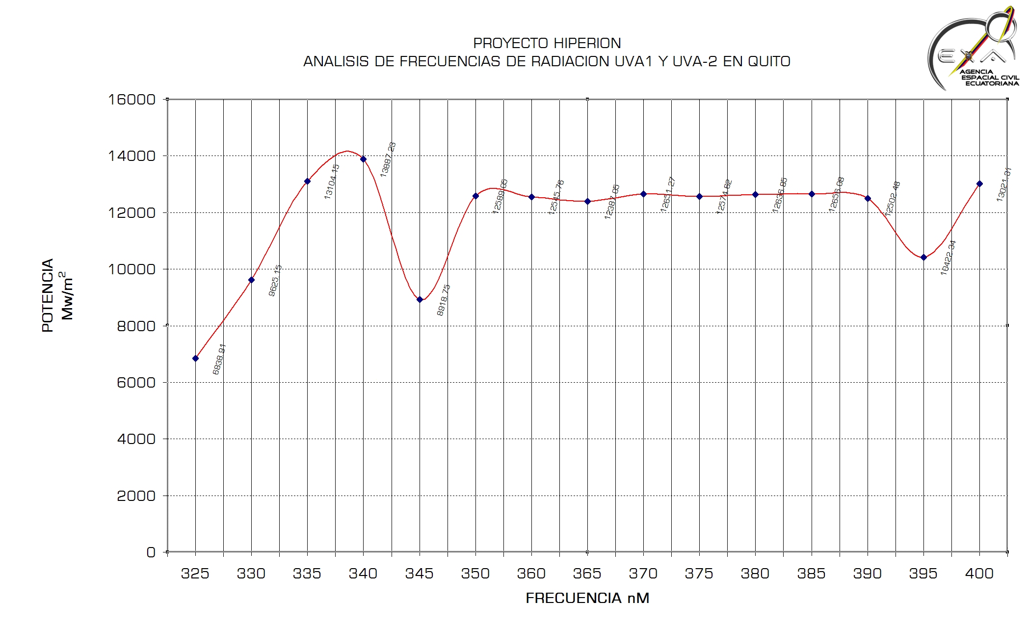
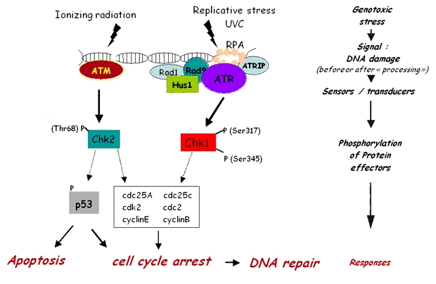
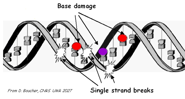
- Due to the high power of the UV-A 340nm radiation it is probable a rise
in the cases of illnesses that arise from DNA damage.
|
|
37
|
- More research is needed in this field in the country and more resources
are needed for this job.
- Childs are to be protected, and something will have to be done about the
times of the day they spend in the open during school time.
- Activities in the open should be taken very seriously from now on.
- Sunscreens should be used, in the coastal, Amazonia and Galapagos areas
they should be of at least SPF 70, in the Andean region should be SPF
100, and they should have UV-B and UV-A protection.
|
|
38
|
- Foreigners visiting our country should be properly informed of this
conditions, so they can take appropriate measures.
- Every vehicle should be equipped with anti-UV windshields films to avoid
exposition in a place where people is trapped and cannot avoid being
exposed.
- The medical community should investigate if there is a clear statistical
correlation between the high UV-A 340nm radiation dose and the apparent
increment of congenital malformations in the last 10 years in Ecuador.
- The state should intervene URGENTLY to protect the Ecuadorian population
from an immediate, clear and present danger.
|
|
39
|
- In an effort to help fight this phenomenon, EXA wants to take the first
step in the protection of the Ecuadorian population..
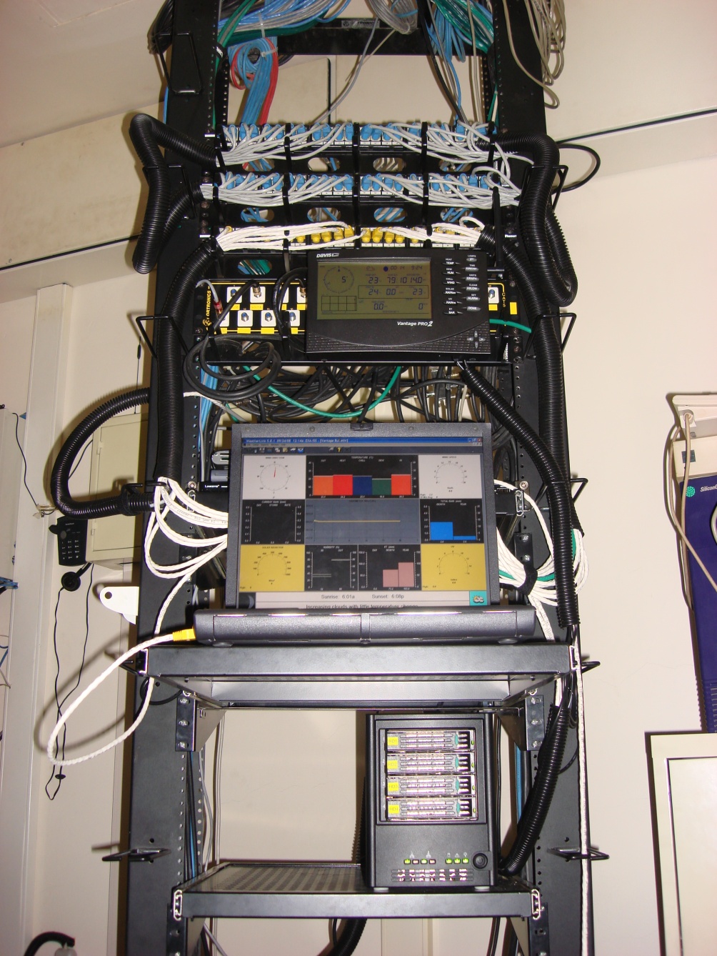
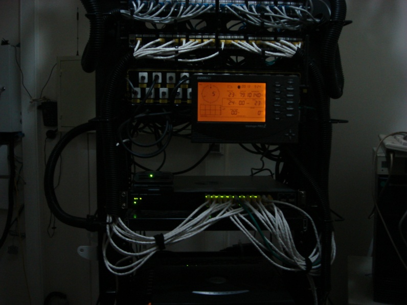
- Using our own resources, science and technology, we have setup 3 systems
that starting today will empower 4 million people with the capacity to
react against high levels of UV radiation.
- The front line system is the NRM: the NATIONAL RADIATION MONITOR, which
is a near real-time system that reports, every 5 minutes which is the
level of UV radiation in Guayaquil and Quito and emites a recommendation
accordingly to the actual UV level.
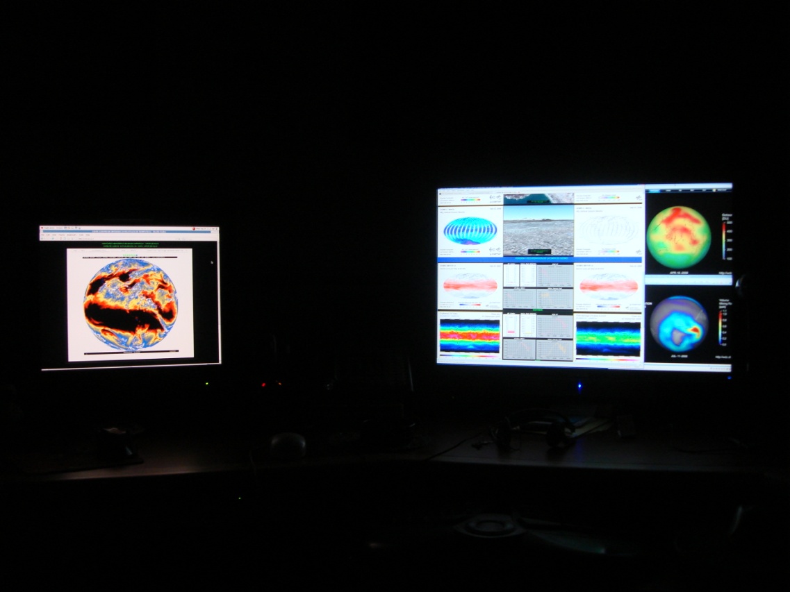
- The second system is the RTSIC: The Real Time Satellite Imaging Center,
a system that gathers images from 10 different meteorological satellites
monitoring UV radiation, clouds and ozone levels from space, this system
will help in the investigation of the phenomenon and will help forecast
radiation surges.
- The third system is the RTCR: Real Time Climate Reporter, which give any
person direct access to the EXA meteorological stations with more than
100 measuring parameters and data history up to 1 year.
|
|
40
|
|
|
41
|
|
|
42
|
- Help is needed from the mass media to maintain a permanent information
campaign for the population in order to help them get aware of the risks
and how to avoid them.
- Real time media like (TV, Radio and Internet) should inform the
population when the UV levels are dangerous, this information can be
taken from the EXA NRM
- Mobile phone companies should use this information to alert its
customers in real-time when the radiation is reaching high levels.
|
|
43
|
- EXA offers the FREE use of their systems to the society, any person,
worldwide, can access them over the internet.
- EXA maintains daily archives of all the information collected by all our
systems so any researcher can make free use of it, as long as there is
no commercial use is involved.
- EXA will notify the diplomatic delegations of the countries affected by
this problem.
|
|
44
|
- HIPERION is part of the Ecuadorian Space Program and has been entirely
developed by EXA.
- Executing the Space Program, we have discovered a very serious problem
for the present and future of our country, thanks to space sciences and
technology.
- We raised the alarm and wanted to go further by giving 4 million people
the power to react and protect themselves, using our own resources and
without help from any other institutions.
|
|
45
|
- In this case, timely and precise information about when the UV levels
are dangerous can mean, in the long term, the difference between a
healthy life and a personal tragedy or even death.
- Over the media and mobile operators weights the SOCIAL RESPONSABILITY of
making this information reach all the Ecuadorian population that needs
it URGENTLY
- We have come forward with this very serious announcement only because it
was necessary: Without this information, the population would be
helpless, unaware of the dangers and being expose to cumulative UV
levels that in many cases would lead to illness and even death.
- Such destiny can be avoided with the information provided by HIPERIÓN.
|
|
46
|
- National Radiation Monitor:
- Real Time Satellite Imaging Center:
- RTCR Guayaquil:
- RTCR Quito:
|

 Notes
Notes